AirScout® is making a significant impact in agriculture with aerial imagery that makes a big difference in a farmer’s and agronomist’s ability to manage high value crops more proactively than ever before.
With AirScout, you see crop health alerts weeks sooner–not just days. Now you can intervene with tailored prescription treatments, created by you or your consultant, before crop yields are significantly threatened.
Below are some of the highlights of AirScout’s patented technologies. The AirScout system is easy to learn, practical to use, and works seamlessly with all other precision farming technologies, including VRT equipment.
This makes AirScout® The Proactive Crop Management Tool™ for farmers, agronomists, marketers, and those working in financial, regulatory, environmental, forestry, and other areas focused on the health and productivity of living plants, as well as the condition of soil and water.

AirScout® Thermal Imagery™
- Sensitive to 3/100° C – Shows where plants have a “stress fever” from any factor, biotic or abiotic
- Reveals plant stress far sooner than reflective technologies – Reads bare soil conditions
- Developed by a farmer, made to work for farmers
- Detects where to intervene against plant stressors weeks ahead of serious crop damage, not just days
- Makes ground truthing faster, easier, and more accurate
- Estimates yields up to 30 days earlier than any other method
- Creates precision treatment files to drive VRT equipment
- Invaluable for planting, during growth, at harvest, and for cover crops
- Monitor field conditions throughout the year for erosion, tile line leaks, and more

AirScout® ADVI™ Imagery
- Advances standard NDVI imaging technology to the next level
- Myriad of colors for higher resolution and more detailed images compared to NDVI
- Reads relative nutrition needs in fields by foliage reflectance
- AirScout Prescription Tool puts applications decisions in your hands – you know your land better than anyone else
- Creates precision “shape” files to drive all makes and models of VRT systems and equipment
- Makes ground truthing faster, easier, and more accurate for plant nutrition needs
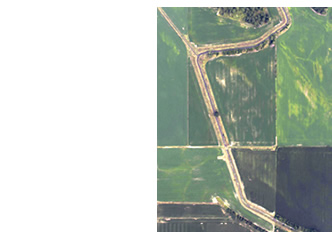
AirScout® Visual Digital Imagery
- Timely, high resolution digital images snap automatically to Google mapping coordinates, which are embedded in AirScout images
- Excellent reference for a wide range of uses
- Verification of crop conditions, spotting anomalies in your fields, lanes, and around buildings
- Images updated every two weeks, or with every AirScout flyover depending on your program or custom needs
DOWNLOAD OUR MOBILE APP

The AirScout® App aids in more efficient and precise field scouting, making treatment prescriptions, and archiving
- Keeps all your images, including custom ones you can manipulate yourself, in one place
- Access from any digital device with an internet connection
- Online tutorial makes AirScout easy to learn and simple to use
- Includes everything you need to connect AirScout image data with the treatment prescription you create with the AirScout Prescription Tool
- Produces precision VRT files for application and early intervention on crop problems, including pests, disease and water stress, as well as plant nutrition.

Download the AirScout® App
- Access your account anytime from anywhere: Desktop, iPhone, iPad
- Use AirScout information out in the field, where it really counts
- AirScout’s custom GPS mapping and guidance steers you to the spot you want to ground truth, see close up to make a stressor diagnosis
- Includes everything you need to connect AirScout image data with the treatment prescription you create with the AirScout Prescription Tool, and then produces precision VRT files for application and early intervention on detected crop problems.

TRY IT FIRST
When you have downloaded the AirScout App, use these login credentials to view the demo folder and see how it works.
Password: demo